")
Geography of the Nile Basin
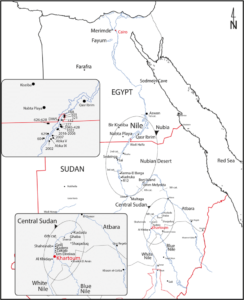
The Nile valley is a region in North-East Africa that runs from the sources of River Nile in the great lakes region of East Africa northwards as the source of the White Nile and the Ethiopian Highlands which are the sources of the Blue Nile. The white Nile is the longest and it’s considered the headwaters of the Nile, however the White Nile looses most of its water through precipitation in the Sudd, a swamp where the white Nile loses half of its water through evapotranspiration. The Blue Nile on the other hand is well watered by the Ethiopian Highlands and contributes 80% of the water. The two rivers join just north of modern day Khartoum, the capital of Sudan.
The river continues with it’s course northwards now as a single great river for some distance before making the famous “S” shaped bend making it the only section of the river flowing southwards. From Khartoum to Aswan, the river passes through six major cataracts before heading smoothly into lower Egypt. Here the river is now in its old stage and its characterized by its slow speed, wide valley and its loaded with silt. Before emptying into the Mediterranean Sea at Alexandria, the Nile splits into a delta.
As we all know, the Nile river flows from South to North, and just like any river, the Nile flows by gravity. Therefore the south is the upper part and the north will be the lower part. This will be a very important thing to note as we shall be discussing Upper Egypt to mean areas close to the source of the Nile whereas Lower Egypt would definitely mean those areas close to the mouth of the river in the Mediterranean.
Leave a Reply